Typhoon No. 1 (Linfa) Brings Heavy Rains to Northeastern Vietnam and Thanh Hóa Province
Hanoi, Vietnam - According to the National Center for Hydro-Meteorological Forecasting, Typhoon No. 1 (Linfa) is moving faster than anticipated and is expected to bring heavy rainfall to the northeastern provinces and Thanh Hóa. The meteorological agency has issued warnings about the potential for thunderstorms, whirlwinds, and strong gusts both before and during the typhoon's landfall.
Development and Trajectory of Typhoon No. 1
The latest updates from the National Center for Hydro-Meteorological Forecasting indicate that Typhoon No. 1 formed from a low-pressure area over the East Sea on the morning of June 22, 2023. As of the current time, the typhoon is moving in a west-northwest direction at a faster pace than initially forecasted.
As of 10:00 AM on June 23, the center of the typhoon is located at approximately 20.0° North latitude; 111.0° East longitude, about 300km east-northeast of the Hoang Sa (Paracel) Islands. The maximum wind speed near the center is level 8-9, with gusts reaching level 11-12.
Characteristics and Intensity of the Typhoon
| Parameter | Value |
|---|---|
| Typhoon Name | Typhoon No. 1 - Linfa |
| Center Location | 20.0°N; 111.0°E |
| Wind Intensity | Level 8-9, gusts level 11-12 |
| Direction of Movement | West-Northwest |
| Speed of Movement | Faster than forecasted |
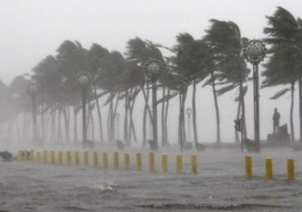
Expected Impacts of the Typhoon
Typhoon No. 1 is forecasted to bring heavy rainfall to the northeastern provinces and Thanh Hóa in the coming days. Rainfall amounts are expected to range from 150-300mm, with some areas potentially exceeding 300mm. The heavy rain could lead to flash floods, landslides in mountainous areas, and flooding in low-lying urban regions.
Additionally, the strong winds and gusts associated with the typhoon may cause damage to houses, buildings, trees, and the electrical system. The East Sea is expected to experience strong winds of level 7-8, with areas near the typhoon center reaching level 9-10 and gusts of level 12-13. Sea waves are expected to be 5-7 meters high.
Primary Affected Areas:
- Northeastern Region: Quang Ninh, Hai Phong, Thai Binh, Nam Dinh, Ninh Binh, Thanh Hoa
- Coastal areas from Quang Ninh to Binh Thuan
- Hoang Sa (Paracel) and Truong Sa (Spratly) archipelagos
Response and Preparedness Measures
In response to the complex development of Typhoon No. 1, the Central Steering Committee for Natural Disaster Prevention and Control has directed provinces and cities in the northeastern region and Thanh Hóa to enhance preparedness measures. Authorities are ready to implement evacuation plans for residents in high-risk areas prone to flooding and landslides.
Power companies in the affected provinces have also been instructed to prepare personnel and equipment to handle power outages and ensure stable electricity supply during and after the typhoon.
Advisories for Residents
The National Center for Hydro-Meteorological Forecasting has issued the following recommendations:
- Residents in coastal areas should proactively protect against strong winds and potential flooding
- Avoid going to the sea or working on boats in areas affected by the typhoon
- People in low-lying areas should take precautions against flooding
- Mountainous residents should be vigilant about the risk of landslides and flash floods
- Government agencies and businesses should inspect and reinforce buildings and structures
Weather Forecast
Over the next 24 hours, Typhoon No. 1 is expected to continue moving west-northwest at approximately 15-20km per hour. By 10:00 AM on June 24, the typhoon's center is forecast to be over land in Thanh Hóa and Nghe An provinces, with its intensity reduced to level 7-8, with gusts of level 10.
Response measures to Typhoon No. 1 are being vigorously implemented to minimize damage to human life and property.
Source: National Center for Hydro-Meteorological Forecasting
#TyphoonNo1 #Weather #NortheasternVietnam #ThanhHoa #NaturalDisasterPrevention